![]()

![]()
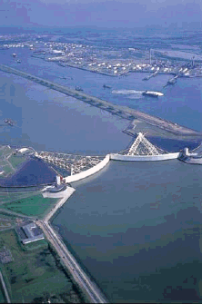
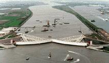
The Maeslantkering
The
An alternative to dike reinforcements in
If a water level of 3.00
metres above NAP is anticipated for
In the event of a storm
tide, the docks are filled with water, so that the hollow gates start to float
and can be turned into the New Waterway. Once the gates meet, the cavities are
filled with water and the gates sink to the bottom, thus sealing off the 360
metre-wide opening. After the high water has passed the gates are pumped out
and the structure begins to float again. Once it is certain that the next high
water will not be another abnormally high one, the two gates are returned to
their docks.
When the New Waterway is
sealed off it is no longer possible for shipping to pass. The storm-surge
barrier will only be closed in extremely bad weather – in probability once
every ten years. A test closure will probably be conducted once a year in order
to check the equipment. This will be done when there is little shipping. With
the rise in sea levels the storm-surge barrier will need to close more
frequently in 50 years time, namely once every five years.
Here you
can see the Maeslantkering!
![[map of the Netherlands]](Geography%20&%20Water%20(Sophie%20Hendriks,%20Patty%20de%20Vos,%20Angelique%20_files/image008.gif)
![]()
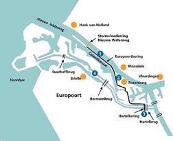
1.Construction of 1-meter high dyke on the Rozenburg
peninsula from the southern abutment of the New Waterway Storm Surge Barrier
towards Rozenburg.
2.Reinforcement of the south-western portion of the water defense
system around Rozenburg. Elevation
of existing dyke. The Europort Barrier then
runs from Rozenburg across the Botlekweg.
At the Welplaatweg the barrier joins up with the A15
via the eastern slope.
3.The
route then runs to the
4.The Brielse
Photo’s
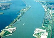
Now the barriers are open
and at the next picture they are closed
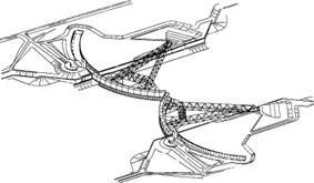
The trusses, each 237 metres in length, are a prominent visual part of the Storm Surge Barrier. Their function is to transmit directly to the ball-joint the loads exerted on the retaining walls in the closure process. During closure the truss will ride up and by approximately 40 centimetres into a camber, levelling out again when the load eases.
Dimensions:
Each arm consists of two separate
open- frame girders joining up at the ball- joint.
|
Length: |
237 meters |
|
Maximum height: |
20 meters |
|
Main girder cross-section:
|
1.80 meters |
|
Main girder
wall-thickness: |
60 - 90 mm |
|
Diagonals cross-section: |
60 - 80 mm |
|
Diagonals wall-thickness: |
12 - 30 cm |
|
Maximum compressive force:
|
300 MN |
|
Tensile force (given
negative head): |
50 MN |
|
Connection with hinge: |
- end-diagonal |
|
|
- tailpiece |
|
Camber: |
8 cm |
The
barriers were constructed with a camber of 500 mm. After removal of the
supports a camber of 80 mm remained. ![[zeeg, katterug]](Geography%20&%20Water%20(Sophie%20Hendriks,%20Patty%20de%20Vos,%20Angelique%20_files/image017.jpg)