 "Hot" image!
| Satellite Images | ||||
Remote
sensing department of MHI is organization with 20
years experience in ocean remote sensing and has software
and hardware for receiving and processing of satellite
information:
|
||||
| Receiving station region overlaps territory from Spain to Mid Asia. MHI has data archives for the Black Sea and East Mediterranean region for last 5 years (2000 images). | ||||
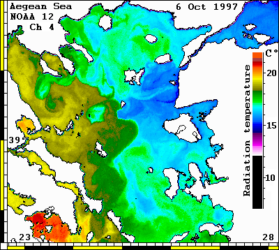
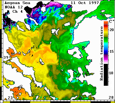
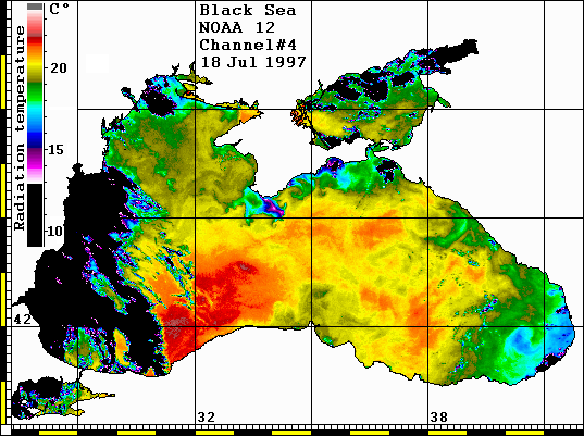
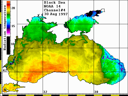
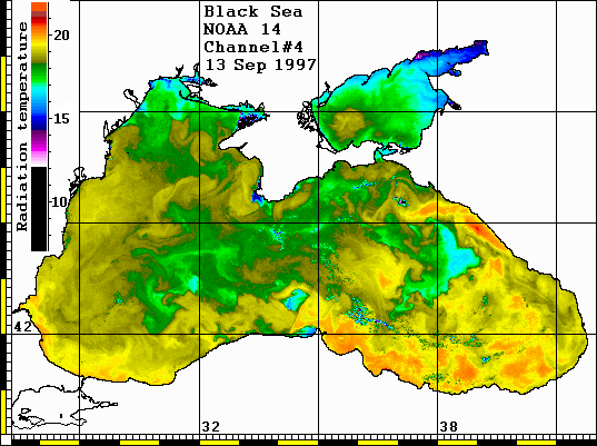
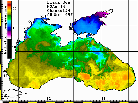
| Main function of software - digitazation and calibration of the satellite images, geographical correction and transformation into the map, multichannel temperature and optical sea water properties calculation, extracting data from images and adding the graphical information, fragmentation and filtering of images, processing the time series of images and animation, combining data from different sources (meteorological map, satellite data, in situ measurements etc.). Radiation temperature maps of the Black and Aegean Sea are presented as example. | ||||
| Contact Dr. Serge Stanichny: [email protected] | ||||
| Selected NOAA & SeaWifs satellites images | ||||
| Black & Aegean Seas Radiance Temperature | ||||
|
|
|||
|
|
|||
|
|
|||
|
|
|||
| More satellite images | ||||
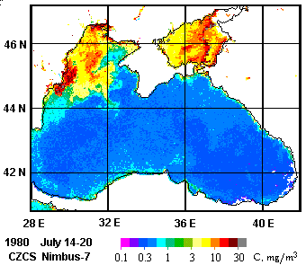
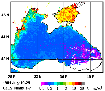
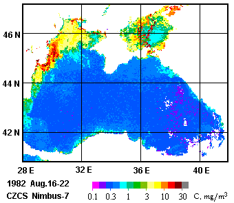
| Nimbus-7 CZCS Phytoplankton Pigment Concentration | ||||
| Oceanographers have developed a range of techniques to measure primary productivity by making observations from ships. These methods are indispensable, however, spatial and temporal coverage of ship-board measurements is sparse. The best method for deriving large-scale information about phytoplankton is with the aid of satellites. NASA developed the Coastal Zone Color Scanner (CZCS) to take advantage in satellite observations of ocean color fields. The CZCS was launched on the Nimbus-7 satellite in October 1978 (Hovis et al., 1980). | ||||
| During its 7.5 year lifetime the CZCS acquired nearly 68,000 images, each covering the area of about 1600x800 square kilometers with 825 m spatial resolution. It measured the visible radiation in four spectral bands, each of 20 nanometers width, and centered at 443, 520, 550 and 670 nm. The specific features of the CZCS are very high sensitivity and rather good calibration and stability of the measuring scales in time. It was the instrument not only for getting the images, but also for the quantutative measurement of the radiation. | ||||
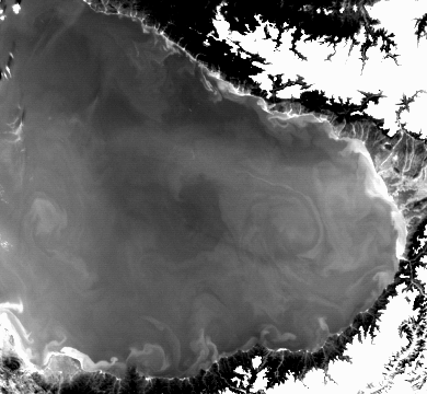
| Due to the power demands of the various on-board experiments the CZCS sensor was operated on an intermittent schedule. Several hundredth images were obtained for the Black sea region. Most of them are in 1979-1983. The main limitation in their usage is cloud cover. Nevertheless, many images are very informative. The typical examples are shown at the pictures. They display both spatial and temporal variability of the bio-optical properties of the sea. This maps are prepared based on the data obtained from NASA. | ||||
| The total CZCS data set was archived and processed by the NASA Goddard Space Flight Center (Esaias et al.,1986), with a consistent set of procedures and represents the most comprehensive source of ocean color measurements to date (Feldman, et al., 1989). Today the CZCS data are stored and distributed by special Ocean Color group in NASA Goddard Space Flight Center, Greenbelt, MD 20771. These Activities are sponsored by NASA's Mission to Planet Earth Program. | ||||
| All the CZCS data for the Black sea were selected from NASA archive, and local database was created in Marine Hydrophysical Institue in Remote Sensing Data Processing and Analysis Laboratory (Head of lab.: V.S.Souetin; e-mail: [email protected]). | ||||
| In August 1997 the new similar to CZCS instrument SeaWiFS (Sea-Viewing Wide Field-of-view Sensor) was launched to the orbit onboard the SeaStar spacecraft. It is the joint project of NASA and private industry (Orbital Sciences Corporation). It is aimed to serve the needs of basic science and commercial applications. | ||||
| REFERENCES | ||||
| 1. Esaias, W.E., G.C.Feldman, C.R.McClain and J.A.Elrod, Monthly satellite-derived phytoplankton pigment distribution for the North Atlantic ocean basin, Eos Trans. AGU, 67, 835, 1986. | ||||
| 2. Feldman, G.C., N.Kuring, C.Ng, W.Esaias, C.McClain, J.Elrod, N.Maynard, D.Endres, R.Evans, J.Brown, S.Walsh, M.Carle and G. Podesta, Ocean color: availability of the global data set, Eos Trans. AGU, 70, 640, 1989. | ||||
| 3. Hovis, W.A., D.K.Clark, F.Anderson, R.W.Austin, W.H.Wilson, E.T.Baker, D.Ball, H.R.Gordon, J.L.Mueller, S.Y. El Sayed, B.Sturm, R.C.Wrigley and C.S.Yentsch, Nimbus-7 Coastal Zone Color Scanner: System Description and Initial Imagery, Science, 210, 60, 1980 | ||||
| Selected Nimbus-7 CZCS satellite images | ||||
| Black Sea phytoplankton pigments concentration | ||||
|
|
|||
| Home Page | About | Data
Directory Metadata Directory | Red Data Book | Related Sites |
||||
[email protected] |
||||
